

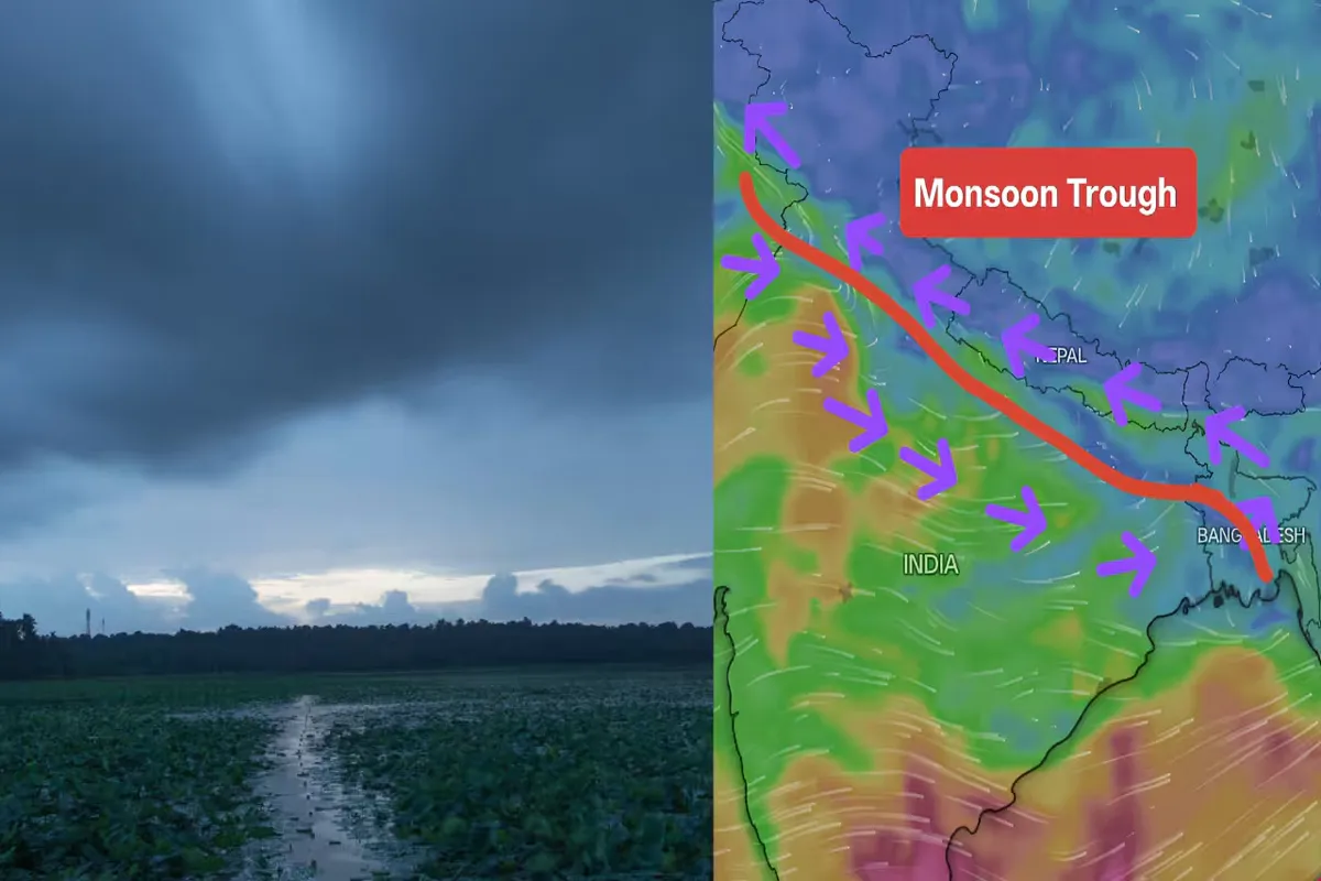
A massive atmospheric shift is underway across the Indian subcontinent. The India Meteorological Department (IMD) has confirmed the formation of a colossal 1,500-kilometer-long monsoon trough stretching all the way from the northern Bay of Bengal to Jammu & Kashmir. This critical weather corridor has significantly accelerated the pace of the Southwest Monsoon, pushing it into 26 states and Union Territories.
As the trough gradually shifts southward into its normal position, meteorologists warn that Northern and Northwestern India will witness a period of intense, widespread downpours between July 1 and July 4.
The 1,500 KM Trough: Breaking Down the Weather System
A monsoon trough is an elongated zone of low atmospheric pressure that effectively acts as a giant vacuum, pulling heavy, moisture-laden winds from both the Arabian Sea and the Bay of Bengal deep into the Indian mainland.
For the past few weeks, this trough hovered close to the foothills of the Himalayas, leaving the northern plains reeling under intense heatwaves and severe humidity. However, with the system expanding and consolidating into a 1,500 km belt, it is now perfectly positioned to dump heavy precipitation across the Indo-Gangetic plains and the northern mountain ecosystems.
State-Wise Impact and Forecast (July 1 – July 4)
The rapid progression of the monsoon has brought immediate relief from heatwave conditions, with temperatures expected to drop by 4°C to 6°C across the northern plains. However, the sheer volume of water carries high risks.
1. High-Alert Mountain Zones (Jammu & Kashmir, Himachal Pradesh, Uttarakhand)
An active Western Disturbance—a moisture-rich storm system originating from the Mediterranean region—is converging with the monsoon trough. This interaction will cause widespread and heavy rainfall across the hilly terrains. The Shimla Met Centre has issued an Orange Alert for several districts in Himachal Pradesh (including Kangra, Mandi, and Shimla), warning of potential cloudbursts, flash floods, and sudden landslides.
2. The Northern Plains (Delhi-NCR, Punjab, Haryana, Western UP)
The long, punishing wait for Delhi residents is finally coming to an end. Widespread showers and thunderstorms are slated to engulf the National Capital Region, Punjab, and Haryana. While the rain will break the humidity, civic authorities are bracing for localized urban waterlogging and traffic disruptions.
3. Eastern and Central India (West Bengal, Sikkim, Bihar)
The tail-end of the trough over the Bay of Bengal is keeping Eastern India incredibly volatile. The IMD has issued a strict warning for Sub-Himalayan West Bengal and Sikkim, predicting extremely heavy rainfall. Rivers like the Teesta and Jaldhaka are experiencing rising water levels, putting low-lying districts on high alert.


2.png)